
Tornado Watch Issued for Monroe and Carbon Counties until 10 pm
THE NWS STORM PREDICTION CENTER HAS ISSUED A * TORNADO WATCH UNTIL 10:00PM EDT Sel8 Spc Ww 082008 Urgent - Immediate Broadcast Requested Tornado Watch Number 278Nws Storm Prediction Center Norman OK410 PM EDT Mon Jun 8 2015
The Nws Storm Prediction Center Has Issued A
* Tornado Watch For Portions Of Northern New Jersey Eastern Pennsylvania
* Effective This Monday Afternoon And Evening From 410 PM Until 1000 PM EDT.
* Primary Threats Include… A Couple Tornadoes Possible Isolated Damaging Wind Gusts To 70 Mph Possible Isolated Large Hail Events To 1.5 Inches In Diameter Possible
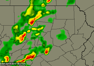
Summary… A Couple Of Longer-Lived Supercell Storms Over Central PaWill Track Across The Watch Area This Afternoon. Low Level Shear IsSufficient For Some Tornado Risk… Although The Main Threat IsProbably Damaging Winds.
The Tornado Watch Area Is Approximately Along And 30 StatuteMiles East And West Of A Line From 70 Miles North Northeast OfAllentown Pennsylvania To 30 Miles South Southwest Of AllentownPennsylvania. For A Complete Depiction Of The Watch See TheAssociated Watch Outline Update (wous64 Kwns Wou8).
Precautionary/Preparedness Actions…
Remember… A Tornado Watch Means Conditions Are Favorable ForTornadoes And Severe Thunderstorms In And Close To The WatchArea. Persons In These Areas Should Be On The Lookout ForThreatening Weather Conditions And Listen For Later StatementsAnd Possible Warnings.
&&
Other Watch Information… Continue… Ww 274… Ww 275… Ww276… Ww 277…
Aviation… Tornadoes And A Few Severe Thunderstorms With HailSurface And Aloft To 1.5 Inches. Extreme Turbulence And SurfaceWind Gusts To 60 Knots. A Few Cumulonimbi With Maximum Tops To500. Mean Storm Motion Vector 26030.